Imagine waking up on a bitter cold winter day 200 years ago and walking across the bay from Camden to one of the nearby islands, even as far as Isle au Haut. In 1820, you probably could have because the ocean’s surface was known to freeze solid in Penobscot Bay. Imagine ice skating on a neighbor’s pond in late March. Winters lasted longer then, so you could have.
Many visitors to Maine today think that the forests that cover 86 percent of the state are natural and untouched. In fact, the landscape looks nothing like it did when Maine became a state — not even deep in the North Maine Woods. Already, by 1820, much of Maine’s forests had been logged. That said, a Mainer who walked through the forest then would have seen stands of trees over 100 years old, something few hikers can see today.
Suburban sprawl, the construction of roads and dams, granite quarrying, coastal development for shipping and later tourism, invasive pests and plants — all of these have dramatically altered the state’s landscapes and waterways in the past two centuries. Here, we examine two other factors that have had a major impact: climate change and logging.
It used to be colder
Like the rest of the globe, Maine is not as cold as it used to be. The Climate Change Institute at the University of Maine has been keeping data on Maine’s temperatures since 1895; that data clearly demonstrates the warming trend.

In the winter of 1905, much of the upper Penobscot Bay was frozen solid, as shown in this photograph at The Monument, a marker a half-mile out in Belfast Harbor. The last big freeze of Penobscot Bay was in 1934. Photo Courtesy of the Penobscot Marine Museum
One result is that the growing season here is up to a month longer than it was 200 years ago, according to Maine State Climatologist Sean Birkel. Many farmers kept (and keep) meticulous records, and scientists study those, able to learn the dates of the first killing frost and the last frost in seasons long past. From that data, scientists know that the average length of Maine’s frost-free growing season is now 12 to 14 days longer than it was just 90 years ago, in 1930. Given current climate change trends, they expect it to increase by another two to three days per decade in the coming years.
The skating season ran longer
Concurrently, the cold season has contracted since statehood, which means that ponds and lakes freeze for less time than they used to, Birkel said. This fact is made clear by records of ice-in and ice-out data kept around the state by water and lake associations. Before statehood, he said, most lakes and ponds in Maine would have frozen solid every winter. Global warming has changed that, he said.
For example, the Portland Water District has kept ice-out data on Sebago Lake since 1807. From 1871 to 1936, Sebago’s big bay froze solid every single winter. In the subsequent 25 years, there were six winters when it did not. And in six of just the last 10 years, the lake’s big bay had open water in winter.
Similarly, records from the early 1800s indicate that Penobscot Bay used to freeze over more regularly, sometimes as far down the coast as Rockland, Birkel said. An 1875 publication quoted an account from the winter of 1780 to 1781, during the American Revolution, that described how the bay had frozen over all the way from Castine to Camden. The last big recorded freeze of Penobscot Bay was in 1934, Birkel said.
The forests look different, too
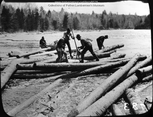
In the 19th century, logging camps spread throughout the northern forestland, and loggers began cutting down big swaths of Maine’s forests. Even the forests that make up the 200,000-acre Baxter State Park — now famous as “forever wild” — were logged many times before Gov. Percival Baxter began purchasing the land, which he eventually gave to the state.
Today, only a tiny fraction of Maine 17.5 million acres of forestland, about 6,000 acres, are uncut old-growth forest, said Mark Berry, forestry director at The Nature Conservancy in Maine. The largest swath of never-logged forest in Maine, and in New England, is the 5,000-acre Big Reed Forest Reserve in the North Maine Woods, which is owned by The Nature Conservancy. The preserve’s oldest trees are over 300 years, Berry said.

Life was primitive at logging camps, like at this one on Socatean Stream north of Moosehead Lake in 1888. Extensive logging has transformed Maine’s landscape. Courtesy of Maine Memory Network
“It basically survived as old growth by a fluke of circumstance,” Berry said. “It’s far from a river or any major stream. So it was never harvested during the log-drive era. Then it was managed by the Pingree family, and they recognized how unique it was.”
When you step into this timber stand, so remote it can only be reached by float plane, it’s immediately obvious it’s a rare place. “It’s a fascinating experience,” Berry said. “There are big trees and old trees – but they’re not staggeringly big. It’s more the complexity of the forest – of all the fallen trees and deadwood of varying ages.”
Send questions/comments to the editors.


